My last hike in North Carolina was the Standing Indian Loop in the Nantahala National Forest.
Standing Indian? Yes, Standing Indian. It’s the name of a couple things in the far south western corner of North Carolina. A very nice campground and a rather large mountain. A place I know my wife got tired of hearing about. What exactly got me talking about Standing Indian?
Getting together a hike is more difficult than one would think. Plans were made at Christmas for our group of 8 to do a 40-mile section of the Appalachian Trail across North Carolina’s Roan Highlands. Six of us were hiking, the other two were to be our shuttles and support. The Roan Highlands is an area of outstanding views and high mountains. As the winter passed everyone rounded up the gear they would need, tried to get out as often as possible to train, and waited for everyone to request and receive the appropriate week for vacation, 1st week of June. As April turned to May problems began to arise. First my hiking buddy Nate couldn’t get that week of vacation as he didn’t have enough seniority and got bumped. Then disaster really struck as my wife Charlotte also couldn’t get that week. She was to be our shuttle to the beginning trailhead and our pickup person 40 miles to the north when our route was through. Two others couldn’t go due to graduations. My sister in Montana and my niece Diana in Connecticut were locked into their vacations and their travel plans made.
I suggested we delay a week but that was not possible for the out-of-towners; not this late. I had to forget about the Roan Highlands for now and find something else involving the Appalachian Trail. I began to research loop hikes along the trail as we now had to start and end in the same general vicinity. I discovered a nice loop hike involving the Appalachian Trail near Standing Indian Mountain in North Carolina. This 24-mile loop would take us up the Kimsey Creek Trail from the Standing Indian Campground, over Standing Indian and Albert Mountains and back down the Long Branch Trail to the campground.
Standing Indian? Does this place exist? I Googled this name and sure enough deep in the Nantahala National Forest there it stood, the 5500 foot Standing Indian Mountain. Seemed perfect to the group which had shrunk to my sister, Diana, Pat and me. And we would spend about 17 miles of the hike and two nights on the Appalachian Trail. Perfect! The trip was set.
My sister arrived from Montana on Monday, and Diana and Pat from Connecticut on Tuesday morning. After Charlotte fixed us a large breakfast we loaded the car and started our journey with a 5-hour drive to the Standing Indian Campground from Raleigh. We had decided to spend the night at the campground, allowing us to get a good early start on Wednesday morning and not be tired from the ride across North Carolina.

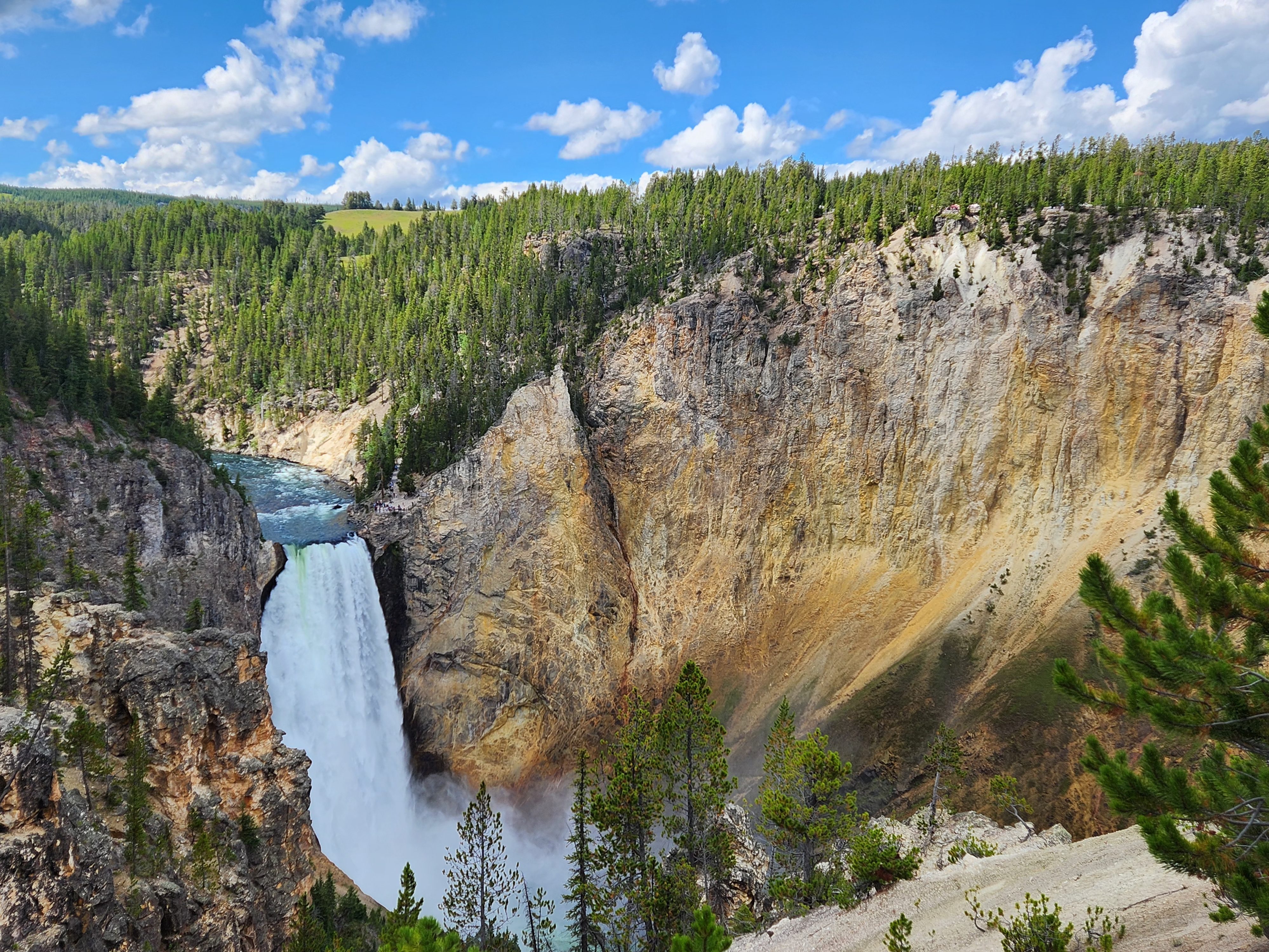
At 5500 feet Standing Indian is the highest summit south of the Great Smoky Mountains on the Appalachian Trail. Standing Indian is an odd name for a mountain. In Cherokee mythology, Standing Indian is the remains of a cowardly Indian. He was sent to watch over the Nantahala Basin where a winged monster was supposed to live. The monster would swoop into the villages and steal children. Upon finding the lair of the monster on the mountain, the Indian brave called on the great spirit to assist him in the destruction of the monster. The great spirit responded with lighting and thunder which frightened the Indian away. He was turned to stone for his cowardice.
We woke up early, had a breakfast of oatmeal and coffee, and broke camp. For two dollars a day you can park at the campground, but we elected to drive around the corner to the backcountry information area where all reports said that a car would be safe for a few days. From the backcountry information area, it is 4.2 miles to the summit of Standing Indian. We headed up the Kimsey Creek Trail, a well-marked footpath; not too steep. It is three miles to Deep Gap, where the trail intersected the AT.

Unfortunately, this gently graded trail didn’t shave much off the 1700 feet we had to climb on this first day to the summit of the mountain. We took a hard left on the Appalachian Trail at Deep Gap and headed for the summit 1.2 miles away and 1300 feet higher. It was quite an upward slog. Near the top we stopped at the Standing Indian Shelter for water and rest. A little farther and we are on the summit of Standing Indian Mountain.


Standing Indian is in the Nantahala National Forest and more specifically the Southern Nantahala Wilderness Area. Nantahala is another of those many Cherokee words so common in this area. It’s meaning, “Land of the noonday sun,” is a fitting name as the sun doesn’t reach the bottom of the area’s deep valleys and gorges until it is directly overhead. The Southern Nantahala Wilderness contains about 23000 acres lying across the North Carolina/Georgia border, with about half the area in The Nantahala National Forest and the other half in Georgia’s Chattahoochee National Forest. In fact, Standing Indian’s summit is only three miles inside North Carolina.
Many who have done this hike recommend camping atop Standing Indian. The sunrises and sunsets they say are beautiful. But we had other plans for more camping and hiking in the Smokies, so we had to press on from here. Our group descended Standing Indian and headed for Beech Gap our first night’s stop and nine miles into our adventure. We arrived at about 3:30 in the afternoon just ahead of a female section hiker.

Beech Gap had three nice sites and dependable water. We picked the large center site, so we would have plenty of room to pitch our two tents. We found water in a spring about 100 yards or so behind the sites. What really made this site stand out was the large stump from a tree that had been cut down just the right height for a table to use as a food preparation area. We got water, and everyone prepared their meal. We were in our tents before sunset. It seems that the climb up Standing Indian wore us all down.
There is an interesting story as to why this loop hike exists. When we took the hard left at Deep Gap earlier in the day we were headed north on the AT but were really walking south. This is the only place on the AT that the trail almost loops over itself as it was laid out to remain on the ridge around the Nantahala Basin instead of descending into it. Albert Mountain’s summit (tomorrow’s climb) is 100 miles north of Springer Mountain Georgia. Many northbound thru- hikers leave the trail at Deep Gap on the Kimsey Creek Trail for supplies and showers at the campground, and re-emerge on the Appalachian Trail at Glassmine Gap after taking the Long Branch Trail back to the AT. Oops! 17 miles and two hard climbs have just been bypassed. So now we have this wonderful loop hike. Logistically, it’s perfect!
We awoke at sunrise, had a breakfast of oatmeal and coffee, broke camp and prepared for our second day on the trail. This day would take us up and over Albert Mountain and into Big Spring Gap where we planned to spend our second night. We left Beech Gap about 8:15 headed for Mooney Gap and the climb up Albert Mountain. At Carter Gap two and a half miles into the day we found evidence of bear activity. A destroyed food bag was found near the shelter.
The American Black bear. It has an insatiable drive to find human food once it has tasted it. On our trip we watched each night as hikers struggled to find a safe hanging for their food. Although it added weight, we opted to carry bear canisters. So much easier and safer for the hiker and the bear. If a bear becomes a problem in its search for human food, it is destroyed!
After a brief rest we left Carter Gap. Next, we descended into Betty Creek Gap where we rested and had lunch.

Albert Mountain stands at 5200 feet with a fire tower on top. Albert Mountain summit is reached by about a mile of steep bouldering. This may explain why many northbound thru-hikers pass through the campground. Albert is just a couple weeks into their quest and the thought of this climb must be daunting.

After about a half hour atop Albert Mountain taking pictures we started our descent into Bearpen Gap. We finally arrived at Big Spring and to our dismay that shelter and its campsites no longer exist. The day’s mileage count stands at 10 but we now must put in another mile and a half to reach the new Long Branch Shelter that has replaced this site.

“Because in the end, you won’t remember the time you spent working in an office or mowing the lawn. Climb that goddamn mountain.”
Jack Kerouac

We reached the Long Branch Shelter area around four in the afternoon. There was equipment there but no one around. We set up our tents on a couple of flat pads that had been built. After a while the female section hiker we had camped next to at Beech Gap came into view. It was her equipment and she was staying the night at Long Branch also. We were later joined by two other section hikers. The camaraderie that night was unforgettable. It’s why we do these hikes besides the challenge. Hikers are the friendliest people on earth. We all share a common goal and common challenges in the back country whether our trip is 25 miles or 2000 miles.

Next morning, we headed out of Long Branch towards Glassmine Gap and our exit from the Appalachian Trail. We turned left and descended the Long Branch Trail towards the backcountry information area and hot showers at the Standing Indian campground!

